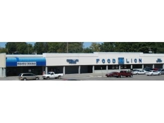
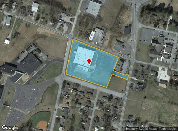
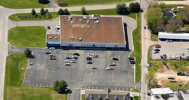
Property Record
281 N Spring St, Sparta, TN 38583
NEARBY LISTINGS FOR SALE OR LEASE
-
-
View all Sparta listings for sale on LoopNet.com
Property Detail
281 N Spring St
049I-A-045.00
Sparta Crossing S/D
Departmentstore
DISTRICT: 1
X
White
47185C0155D
Tennessee
0
1
2024
4.50 AC
935300
Tennessee Central Area
36,436 SF
Other Market Areas
DEMOGRAPHICS near 281 N Spring St
1 Mile
3 Mile
5 Mile
2024 Total Population
1,746
8,525
12,362
2029 Population
1,879
9,187
13,330
Pop Growth 2024-2029
+ 7.62%
+ 7.77%
+ 7.83%
Average Age
43
42
42
2024 Total Households
707
3,462
4,968
HH Growth 2024-2029
+ 7.64%
+ 7.71%
+ 7.73%
Median Household Inc
$45,968
$41,086
$43,388
Avg Household Size
2.40
2.40
2.40
2024 Avg HH Vehicles
2.00
2.00
2.00
Median Home Value
$179,255
$166,574
$165,914
Median Year Built
1978
1976
1978
Nearby Places
Map Layers
Map Styles
 Street
 Aerial
- Restaurants
- Banks
- Shops
- Fitness
- Groceries
Nearby Properties
Address
Land Use
TOTAL SIZE
Lot Size
Zoning
Address
Land Use
TOTAL SIZE
Lot Size
Zoning
54,720 SF
18.57 AC
Address
Land Use
TOTAL SIZE
Lot Size
Zoning
138,852 SF
13.66 AC
MI
Address
Land Use
TOTAL SIZE
Lot Size
Zoning
158,321 SF
19.32 AC
CD
Address
Land Use
TOTAL SIZE
Lot Size
Zoning
68,765 SF
15.12 AC
M1
Address
Land Use
TOTAL SIZE
Lot Size
Zoning
257,014 SF
16.07 AC
CD
Address
Land Use
TOTAL SIZE
Lot Size
Zoning
149,128 SF
13.86 AC
MI
Address
Land Use
TOTAL SIZE
Lot Size
Zoning
3,476 SF
3.14 AC
Address
Land Use
TOTAL SIZE
Lot Size
Zoning
19,112 SF
11.40 AC
Address
Land Use
TOTAL SIZE
Lot Size
Zoning
22,144 SF
5 AC
Address
Land Use
TOTAL SIZE
Lot Size
Zoning
20,020 SF
13.81 AC
Address
Land Use
TOTAL SIZE
Lot Size
Zoning
36.30 AC
CD
Address
Land Use
TOTAL SIZE
Lot Size
Zoning
25,120 SF
13.70 AC
MI
Address
Land Use
TOTAL SIZE
Lot Size
Zoning
28,377 SF
5.30 AC
CD
Address
Land Use
TOTAL SIZE
Lot Size
Zoning
12,758 SF
4.26 AC
CD
Address
Land Use
TOTAL SIZE
Lot Size
Zoning
11,616 SF
1.81 AC
CD
Address
Land Use
TOTAL SIZE
Lot Size
Zoning
93,907 SF
10.79 AC
MI
Address
Land Use
TOTAL SIZE
Lot Size
Zoning
12,597 SF
5.20 AC
CD
Address
Land Use
TOTAL SIZE
Lot Size
Zoning
10,800 SF
3.66 AC
CD
Address
Land Use
TOTAL SIZE
Lot Size
Zoning
46.70 AC
Address
Land Use
TOTAL SIZE
Lot Size
Zoning
12,046 SF
0.11 AC
CC
Address
Land Use
TOTAL SIZE
Lot Size
Zoning
19,188 SF
2 AC
Address
Land Use
TOTAL SIZE
Lot Size
Zoning
84,786 SF
10.43 AC
MI
Address
Land Use
TOTAL SIZE
Lot Size
Zoning
29,943 SF
15.65 AC
CD
Address
Land Use
TOTAL SIZE
Lot Size
Zoning
4,866 SF
7.94 AC
RB
Address
Land Use
TOTAL SIZE
Lot Size
Zoning
3,520 SF
1.24 AC
RB
Address
Land Use
TOTAL SIZE
Lot Size
Zoning
6,592 SF
8 AC
CD
Address
Land Use
TOTAL SIZE
Lot Size
Zoning
91,456 SF
6 AC
M1
Address
Land Use
TOTAL SIZE
Lot Size
Zoning
29,604 SF
8.12 AC
MI
Address
Land Use
TOTAL SIZE
Lot Size
Zoning
6,184 SF
0.51 AC
RA
The World's #1 Commercial Real Estate Marketplace
Connect with us
© 2026 CoStar Group
The information above has been obtained from sources believed reliable. While we do not doubt its accuracy we have not verified it and make no guarantee, warranty or representation about it. It is your responsibility to independently confirm its accuracy and completeness. Any projections, opinions, assumptions, or estimates used are for example only and do not represent the current or future performance of the property. The value of this transaction to you depends on tax and other factors which should be evaluated by your tax, financial, and legal advisors. You and your advisors should conduct a careful, independent investigation of the property to determine to your satisfaction the suitability of the property for your needs.